|
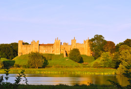 Framlingham
Castle (2¾ miles by foot) Framlingham
Castle (2¾ miles by foot)
One
of the most impressive castles in England, dating from the 12th
century. Mary had readied her forces at Framlingham Castle when she
was proclaimed Queen of England on 19 July 1553. There is strong
evidence that she led her thousands-strong army from Framlingham Castle
along
Queen Mary's Lane on her way to London, where she eventually became the
first woman to be crowned Queen of England in her own right.
Framlingham
Castle is cared for by English Heritage. The earth works, meres and
stunning surroundings are accessible at all times without charge.
However, there is a charge to enter within the curtain walls of the castle, including access
to the wall walk and museums within. Click on the photo to visit the
English Heritage
site for opening times and details of frequent special events.
|
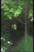
Woodland
Trust, Pound Farm, Great Glemham (adjacent)
The Woodland Trust purchased Pound Farm in the 1990s, and planted it
over with broad-leaf trees, adding to the pockets of old woodland
already there.
Pleasant walks may be taken through the woods and meadows. There is a
car-park from which we have sign-posted a 2.5 mile / 4km circular walk
that follows Queen Mary's Lane before returning through Pound Farm to
your starting point.
Follow the `Circular Walk' link in the menu on the left. Or,
to access the Woodland Trust site, click on the photo to the right. |
Other Connecting Walks
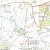 Click
or tap to see a map of the public bridleways and footpaths that connect
Queen Mary's Lane to nearby villages including nearby pubs: Sweffling White Horse, Great Glemham Crown, Rendham White Horse, or those in Framlingham (see 'Visit Framlingham' below). Click
or tap to see a map of the public bridleways and footpaths that connect
Queen Mary's Lane to nearby villages including nearby pubs: Sweffling White Horse, Great Glemham Crown, Rendham White Horse, or those in Framlingham (see 'Visit Framlingham' below).
Alternatively, you can swipe or scroll around the footpaths visually on the Ordnance Survey courtesy of streetmap or use the on-foot route finder of openstreetmap interactively by dragging the red and green 'map pins'.
|
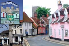 Visit Framlingham (2¾ miles by foot) Visit Framlingham (2¾ miles by foot)
A well as the castle, Framlingham offers pubs, shops, eating out and
pleasant walks. Click or tap on the picture to access the 'Visit
Framlingham' site.
|
Nearby Walks
|
|
|
|
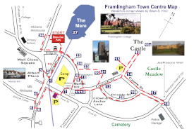 Fram Town Trail (2¾ miles away by foot) Fram Town Trail (2¾ miles away by foot)
27 interesting sights to spot on a short trail around the centre of Framlingham
|
|
|
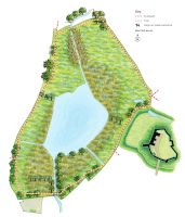 Fram Mere Nature Trail (3 miles away by foot) Fram Mere Nature Trail (3 miles away by foot)
A pleasant (and usually a bit muddy) walk around the 12 hectare Suffolk
Wildlife Trust Reserve with stunning views of Fram Castle and Fram
College
|
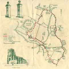 A
circular walk around Parham (passes less than ¾ mile away by foot) A
circular walk around Parham (passes less than ¾ mile away by foot)
Taking in Moat Hall, Parham Church, Parham
Wood and Parham's three greens (Long route 1h 40mins; Short 1h).
Leaflet courtesy of Suffolk County Council.
|
|
|
 7-Mile Walk from Wickham Market station to Framlingham 7-Mile Walk from Wickham Market station to Framlingham
A
lovely walk across country from Wickham Market Station (in Campsea
Ashe) to Framlingham. Courtesy of Suffolk On Board.
This fascinating description of the same walk tells of every little piece of legend and history along the way.
And here's another map of the same walk with perhaps clearer instructions.
Using part of this walk, Wickham Market Station is 5½ miles away by foot, or a little more if you want to avoid more roads (openstreetmap is useful).
|
 Sweffling White Horse: Local Walks Sweffling White Horse: Local Walks
Local Walks based around the Sweffling White Horse pub, which is 3¼ miles away by foot.
|
|
|
 The Brownsord Way - 12-Mile Circular Walk around Framlingham The Brownsord Way - 12-Mile Circular Walk around Framlingham
The Brownsord Way connects up nearly 12 miles of public rights of way
encircling Framlingham, 90% of which is off-road.
It can be reached from
Queen Mary's Lane via about ¾ mile of public bridleway called the
Packway, which crosses Queen Mary's Lane on its route between Parham's North
Green and Great Glemham. |
 Parham Airfield Museum (about 2 miles by foot) Parham Airfield Museum (about 2 miles by foot)
WWII museum on Parham Aerodrome, including the museum of the secret British Resistance Organisation. |
|
 Local Pubs Local Pubs
You can use the bridleways mapped above to cycle or walk to nearby pubs in three neighbouring villages:
As well as the four pubs in Framlingham (about 3 miles – see 'Visit Framlingham' below). |
A Little Further Afield
 Suffolk Coasts and Heaths (13 miles away) Suffolk Coasts and Heaths (13 miles away)
Area of Outstanding Natural Beauty. Stretching from Southwold down to
Old Felixstowe, taking in Walberswick, Blythburgh, Dunwich, Minsmere,
Thorpeness, Aldeburgh, Orford, Shingle Street and Bawdsey.
The Suffolk Coast path covers the 60 miles of coastline from Lowestoft
to Felixstowe and includes small foot or bicycle ferries crossing the
Blyth, Ore and Deben estuaries. Alternatively, the Sandlings Walk runs
roughly in parallel a little further inland.
|
|
|
|


