Queen Mary's LaneCircular WalkThe Lane's History Queen Mary's March Flora & Fauna Nearby |
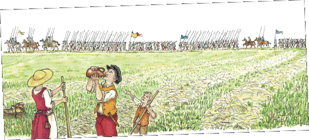
‘The infantry made ready their pikes, the cavalry brandished lances, the archer bent his bow, and girded on his quiver, the harquebusier filled his weapon with powder, and all men stood in place not moving a finger’s breadth from position’.
From Robert Wingfield's contemporary record of Queen Mary's muster at Framlingham Castle on Thursday 20th July 1553, a few days before her march to London to reclaim the crown from Lady Jane Grey [1554a].

By Agnes Strickland, Elizabeth Strickland [1848a]
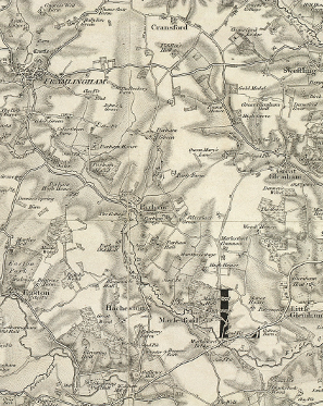
"From the steeple of the church of Framlingham the sea-port of Aldborough may be seen. The castle stands at a much greater elevation, and its highest watch-tower, when entire, commanded a view of the German ocean, and all that passed near the coast, which circumstance was likely to prove of great utility to Mary, who meant to retreat, in case of danger, by the nearest road to the sea. To this day a lane, about a mile and a half from the castle, leading to the coast, is called 'bloody queen Mary's lane,' because it is reported she used to walk there,—that is, like a prudent general, she surveyed the roads by which retreat was to be made if needed. The close and winding lanes which led through the forest surrounding Framlingham-castle, were rendered impassable by trees felled and thrown across them."
According to the Strickland sisters, Queen Mary marched from Framlingham on 31 Jul 1553 and reached Ipswich the next day. However, according to Robert Wingfield's contemporary account [1554a], Mary stayed in his town house on Tacket Street in Ipswich from 24 to 26 Jul 1553.
Two pages later the Strickland sisters' account says "Five hundred men were appointed to guard the queen within the walls of the fortress [JPrivyCouncil] and no persons, whether coming to submit themselves, or otherwise, were permitted to approach her without order from the council." Therefore it seems highly unlikely that Mary would have taken a walk along a local lane during her stay, rather than sending out scouts.
 "Southwold and
its vicinity, ancient and modern" (click the book to
read p324
online)
 By Robert Wake [1839a]
"The first of the Howard family who possessed the castle was John, son of Sir Robert Howard, whose mother was the Lady Margaret, daughter of Thomas Mowbray, the first Duke of Norfolk; in this family it remained till the year 1635, when it was sold to Sir Robert Hitcham for fourteen thousand pounds. It may be further worthy of notice, in taking leave of this venerable building, that King Edward VI. granted it to his sister, the Lady Mary, with several annexed lordships and domains. Upon the occasion of his premature death, and the assumption of title of Queen by the Lady Jane Grey, Mary retreated from Kenninghall, in Norfolk, to her castle, for better security, and for the facility which, on account of its vicinity to the sea, it would afford her for escape to the continent in the event of the success of Lady Jane's party. It was here, moreover, that Mary first assumed the royal title, and where her principal adherents joined her. There is a small part of the castle which still retains the name of " Queen Mary's Room" and a lane is yet denominated " Bloody Queen Mary's Lane." " In this lane," says the author of the pamphlet before quoted, " she probably used to walk ; " but it has been asserted that a road, or " lane," was expressly formed to facilitate her escape eastward towards the sea, should a flight from the castle become necessary. "
Unfortunately, the 'pamphlet before quoted' is just referred to as a pamphlet about Framlingham castle, without any details.
By James Bird [1831a]
A note to this canto contains the same text as the later account above.
"There is a small part of the castle which still retains the name of Queen Mary's Room and a lane is yet denominated Bloody Queen Mary's Lane. In this lane says the author of the pamphlet before quoted she probably used to walk but it has been asserted that a road or lane was expressly formed to facilitate her escape eastward towards the sea should a flight from the castle become necessary."
By R. Green [1834a]
"At the end of July, or beginning of August, after the earl Arundel's visit, Mary quitted the Castle for London,* where she arrived on the third of the latter month, and was proclaimed queen, the odious features of whose fortunately short reign, of little more than 5 years, were the restoration of the ancient religion of the kingdom, and the well known bloody persecution of the eminent persons by whom tenets of the reformed church had been propagated and upheld.
* In the parish of Cransford, about a mile and an half up the Saxmundham road, is a spot which has always been called "bloody queen Mary's lane," at the entrance to which there is a pack gate still kept up, though not used, to denote the spot. The tradition is that she used to walk there, but, for the few days she remained in Framlingham this is not to be credited, the greater probability is, that on leaving the Castle she proceeded in this direction with her train of adherents and men of arms for the Metropolis. Another opinion has been at times advanced, that it was a road or lane expressly formed to facilitate her escape eastward towards the sea, in the event of her flight from the Castle becoming necessary,—this might not be improbable."

"The Beauties of England and Wales, or, Original Delineations, Topographical, Historical and Descriptive, of Each County" (click the book to read v. XIV p299 online),
By Frederic Shoberl [1819a]
"On the death of that prince his sister Mary, who was then at Kenninghall, in Norfolk, having asserted her claim to the throne in opposition to the powerful partisans of Lady Jane Grey, repaired for the greater security of of her person to the Castle of Framlingham*, where she resided till her removal to London, to take possession of the crown.
* Tradition has perpetuated the memory of Mary's residence at this place, by many stories, without doubt, the invention of zealous Protestants, to whom this princess afterwards proved so cruel a scourge. Among others, it was asserted and believed by many, that she was delivered in this castle of a monster, which, in a paroxysm of horror she instantly destroyed, and not many years since, the stone on which she is said to have dashed it, continued to be pointed out. A small part of the castle still remaining is called Queen Mary's room, and a lane, in which she probably used to walk, yet retains the appellation of Bloody Queen Mary's Lane."

