Queen Mary's LaneCircular WalkThe Lane's History Queen Mary's March Flora & Fauna Nearby |
Contents
- The Evolution of Queen Mary's Lane
- Prehistory
- Bloody Queen Mary
- Traces of Evidence
- Decline
- Queen Mary's Wood
- The Sowing of Queen Mary's Plantation
- Disappearance
- Reopening
- Parham's Medieval Tracks and Lanes
- References
The Evolution of Queen Mary's Lane
By Bob Briscoe, based on his contribution to the Parham Millennium Scan in Jan 1999, in turn based on a text originally written by Stephen Podd in conjunction with Miss Gwen Dyke.Prehistory
Although the name of Queen Mary's Lane is thought to stem from events occurring in 1553, Queen Mary's Lane is much older, almost certainly in excess of 1000 years. This is supported by the sunken nature of the remaining length alongside Queen Mary's Wood today, with hedges on either side sitting atop widely spaced high banks. The lane must have existed at the time when the parish boundaries were first defined (tenth century at least and probably much earlier), as it was the marker of Parham's eastern boundary. It was also a boundary of Parham Half-Hundred[i], one of the 25 early administrative divisions within the county.
 Bloody
Queen Mary
Bloody
Queen Mary
Local legend has it that the modern name of the lane dates from when Queen Mary led her army in triumph to London, where she was to claim the crown from Lady Jane Grey. On 12 July 1553 Mary arrived at Framlingham Castle, from Kenninghall in Norfolk, to collect her forces thinking she would need to depose Lady Jane by force. However, by 19 July 1553, Jane's support had collapsed and the Privy Council in London declared Mary Queen, news of which reached her in Framlingham the following day. On 24 July 1553, she set out for London, heading first for Ipswich where she stayed until the 26th.
Georgian and Victorian histories (detailed here) mention Queen Mary's Lane and conjecture diverse reasons for its name. Variously; that:
- "she used to walk there";
- that "she proceeded in this direction with her train of adherents and men of arms for the Metropolis";
- or that "it was a road or lane expressly formed to facilitate her escape eastward towards the sea, in the event of her flight from the Castle becoming necessary".
Traces of Evidence
Quite how far the lane originally ran is not entirely clear. Short lengths survived north and south of Queen Mary's Wood well into the twentieth century. Eighteenth and early nineteenth century maps confirm that it extended south along the parish boundary to a point east of present day Crabbe's Farm, under Parham airdrome [1747b].
| The right-hand of these maps [1747b] shows North Glemham Farm (present-day Paul's Grove Farm) as surveyed by William Brasier in 1747. Queen Mary's Lane is shown running along the western boundary, and Procession Field can be seen in the centre of the map. |
 |
| (Click
thumbnail
to view) Reproduced with the permission of SRO |
A lane continuing southward in the same line as Queen Mary's Lane is just visible at the bottom of the above map of North Glemham Farm, having crossed the "Way from Hatcheston & Parham to No Glemham", which is today under Parham airdrome, and replaced by a diverted bridleway that skirts the airdrome parallel to its original course. No evidence of use of the name "Queen Mary's Lane" beyond this staggered cross-roads has (yet) been found. From this point the course of Queen Mary's march is also uncertain. The ancient way may well have continued along surviving lengths of `green lane' north and east of `The Willows' at Marlesford (in part the boundary between Plomesgate and Loes Hundreds), crossing present day `Keeper's Lane' to follow `Hollow Lane' to Marlesford, meeting the London Road near Marlesford `Bell'.
At the northern end there is some evidence that the lane
continued to
follow the parish boundary to Boundary Farm. The `Z' bend in the
present
day Saxmundham Road is a clue that this was once a staggered
junction
across the more important lane. Also the name of the field that
straddles
the parish boundary here is called `Cross Path Field'. A late C18 map
of what is now Oak Farm [1794a]
labels the top end of the lane as the route to Framlingham,
tantalisingly continuing
off the top of the map along the Parish boundary towards Boundary Farm,
rather than past Little Lonely Farm as the road to Framlingham does
today. Continuing
further
north, it seems more than co-incidence that a number of straight
portions
of footpath and track continue to Framlingham Hall in Dennington, the
other side
of
the Roman Road to the north of Framlingham. Indeed, this line of
footpaths and field boundaries continues through Dennington Place,
Braiseworth Hall, Tannington Place and possibly onward to Worlingworth
Street.
Decline
Presumably the lane originally became important because it runs along the watershed between the higher reaches of the rivers Alde and Ore, avoiding the flood plains and mud in the valleys either side. By the 1790s the lane had declined in use and importance, perhaps due to improvements to alternative routes through the valleys, or perhaps because over the centuries it had become sunken relative to the banks either side as evidenced by the remaining section alongside Queen Mary's Wood. By 1761, Queen Mary's Lane is shown having a southern ending on the lane from present-day Silverlace Green to Great Glemham, there being a `T' junction [1761a] where just fourteen years earlier there had been a staggered cross-roads [1747b].| 1761 map of Parham New Park (Park Farm today) [1761a] showing Queen Mary's Lane ending at a `T' junction where fourteen years earlier there had been a staggered cross-roads. |
 |
| (Click thumbnail to view) |
A map of what is now Oak Farm, Parham, surveyed in 1794, shows that Queen Mary's Lane was the way used to reach the farm from the Saxmundham Road, and the present track to the farm from the Cransford Road wasn't shown at all [1794a]. However, on the survey sketches for modifications to the original (drawn before 1819 [1802a]) the present day track had appeared, and the surviving length of Queen Mary's Lane from the Saxmundham Road, through the edge of Queen Mary's Wood and beyond had been planted with trees—the map dates their planting at 1795.
| 1794 map [1794a] showing dates
of
Oak planting in Queen Mary's Wood and along Queen Mary's Lane. The map incorporates later adjustments down to the year 1819. |
1802 survey sketches to prepare for the
adjustments to
the map on the left by the surveyor Isaac Johnson [1802a] |
 |
 |
| (Click thumbnails to view) | |
|
Click on the thumbnails to the right to view full-size field-name maps of Parham in 1838 (or in PDF format here [ North / South ]). The maps were traced from the 1838 Ordnance Survey Tithe Map of Parham [1840a] by Bob Briscoe for the 1999 Parham Millennium Scan, which explains all the names and numbers. By this time
(c.1840) other evidence that we introduced above shows
that much of the lane further
south had been encroached by
farmers and ploughed out. |
 |
 |
Queen Mary's Wood
 The
above 1794 map states that Queen Mary's Wood
(sometimes called Queen Mary's Covert) was planted in
1788, on the Great
Glemham side of
Queen Mary's Lane. This implies either that the wood
was named after the lane,
or that in 1788 trees were planted on the site of a wood that
had
existed in 1533 when it might have been renamed Queen Mary's Wood.
Today there
is no evidence of trees within the wood older than about 1900. However,
in the opinion of
the late local historian, Miss Gwen Dyke, Queen Mary's Wood is in the
classic position of a Medieval `pig wood'—half way
between villages on the watershed between two
valleys. It is
reasonable that the oaks planted in 1788 would have been ready for
harvesting around 1900, when it appears that it was replanted
primarily with hazel and ash for coppicing. By the 1970s
coppicing
was no longer routinely practised, but timber was taken as needed. In
1984 Paul Briscoe re-established a twenty-year coppicing
rotation and to this day (2014) we still coppice a quarter of the wood
every five
years.
The
above 1794 map states that Queen Mary's Wood
(sometimes called Queen Mary's Covert) was planted in
1788, on the Great
Glemham side of
Queen Mary's Lane. This implies either that the wood
was named after the lane,
or that in 1788 trees were planted on the site of a wood that
had
existed in 1533 when it might have been renamed Queen Mary's Wood.
Today there
is no evidence of trees within the wood older than about 1900. However,
in the opinion of
the late local historian, Miss Gwen Dyke, Queen Mary's Wood is in the
classic position of a Medieval `pig wood'—half way
between villages on the watershed between two
valleys. It is
reasonable that the oaks planted in 1788 would have been ready for
harvesting around 1900, when it appears that it was replanted
primarily with hazel and ash for coppicing. By the 1970s
coppicing
was no longer routinely practised, but timber was taken as needed. In
1984 Paul Briscoe re-established a twenty-year coppicing
rotation and to this day (2014) we still coppice a quarter of the wood
every five
years.
or for gaine other lande; that is to cutt down smalle trees called maples and likewise thornes."
 The Sowing of Queen Mary's
Plantation
The Sowing of Queen Mary's
Plantation
In 1890, the owner of
most of Parham's land, Frederick
Corrance, arranged for the pupils of Parham School to bring
acorns
up to Great Horse Close on the Glemham boundary between Oak and Elm
Farms,
which was then arable. Over the ensuing century, the acorns have grown
into a great wood of straight oaks, all now approaching maturity.
My source for this story was my father, Paul Briscoe. He also
wrote it into handouts that he produced for farm
visits, but I have no record of his historical source. The date of 1890
is supported by the map evidence, because the 1888 Ordnance Survey
(below) shows no plantation, whereas the 1904 edition does. It is also
supported by tree ring evidence.
On the Ordnance Survey it is has always been called Queen Mary's
Plantation since it first appeared on the 1904 edition. But locally it
is called Queen Mary Firwood, despite there being no
firs
today. On the 1904 Ordnance Survey the wood is filled with fir tree
symbols. Then by the 1940s, it becomes mixed with a single long ride
down the middle. In the 1950s it becomes completely deciduous, still
with a single ride. Presumably
the firs
were originally planted for early cover and to
encourage the oaks to grow straight and tall, then thinned out. Today,
two
rides
cross each other, dividing the wood into equal quarters, and there is a
grid of coppiced hazels under the oaks, with no sign of any firs. In
contrast, the oaks are planted randomly, with no regularity.

Disappearance
Click on the thumbnail
to the right to view part of the first Ordnance Survey map of
Suffolk from 1888. It clearly shows the
line of
Queen Mary's Lane even though much of it was no longer
passable by this
date.
The 1903, 1927, 1946 and 1957 editions of the Ordnance Survey all show copse along Queen Mary's Lane to the north and south of Queen Mary's Wood and alongside it [nls2015]. The copse to the north was ploughed out in c.1975 and no longer appeared on the 1978 Ordnance Survey. In the late 1970s the strip of covert covering the section south of Queen Mary's Wood (since 1795) was ploughed out as well.
Reopening
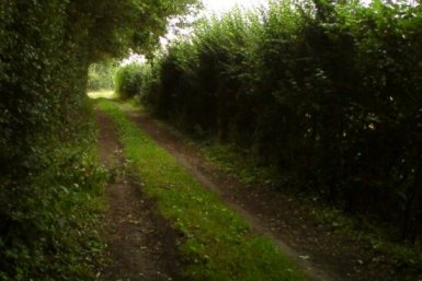
In March 2014, we opened up Queen Mary's Lane as a permissive bridleway. Before this, none of the route was even a right of way, except for the `Z' bend in the Framlingham to Saxmundham road, which staggers across this ancient green lane.
In 2014 only one
segment of the original Queen Mary's Lane remains: where double
ditches one lane's width apart run within the western edge
of Queen Mary's Wood. In
the 1990s, Paul Briscoe and Alfred Whymark felled and uprooted the
trees that made this section of Queen Mary's Lane nearly
indistinguishable from Queen Mary's Wood. As you step out of the wind
into this passageway,
a quietness takes over and you can imagine the awe of the peasants
working these fields as a thousands-strong army
marched through here, headed by Queen Mary on her white horse.
To the south of Queen Mary's Wood, nowadays you have to switch to the track on the opposite side of the ditch from the original lane. This continues along the eastern edge of Queen Mary's Plantation through a tunnel made by the high hedge. Continuing south, there is a wiggle in the parish boundary, but the two fields either side have been ploughed together, so the ancient lane is not visible on the ground. The permissive bridleway skirts round this gap and returns to the lane where it crosses the Packway, a bridleway towards Glemham on one side and North Green on the other.
Permissive public access along Queen Mary's Lane continues for one more field over the Kindred's land, but the permissive path then turns towards Glemham, whereas the line of the ancient lane continues forwards, through Paul's Grove, under the airdrome and onward. The only other possible remains of the lane are in Paul's Grove where a track's width clear of trees sweeps through the grove, even though trees grow copiously on either side.

Parham's Medieval Tracks and Lanes
By Bob Briscoe (based on a chapter of Parham's Millennium Scan, Jun 1999)
 Click on this thumbnail to view the
full-size map in a separate window (or as a PDF
format map). This sketch map suggests a possible layout of Parham
at some
time between 1433 and 1550. A detail of Queen Mary's Lane from this sketch map is shown below to the right.
Click on this thumbnail to view the
full-size map in a separate window (or as a PDF
format map). This sketch map suggests a possible layout of Parham
at some
time between 1433 and 1550. A detail of Queen Mary's Lane from this sketch map is shown below to the right. There is very little hard evidence of the layout of medieval Parham, but, rather than say nothing because no-one is sure, we offer an educated guess. The map and the words that follow should not, in any way, be quoted as gospel. They represent a feeling of how the village may have been laid out based on clues in field names, the history of the houses and the existence of sketchy evidence of old tracks either on the ground today or on old maps. The sketch builds on a similar conjecture map sketched by the late Gwen Dyke [Dyke198x]. In turn, that sketch map was largely based on the 1433 manorial `Extent', which describes the Howard estate that stretched from Rendlesham to Framlingham north of the River Deben [1433a].
A main road is thought to have run from Letheringham Old Hall to Colston Hall across Parham bridge and through Northland Green (North Green). The stretches from Easton to Parham (Footpath No.2) and north of Cransford are both just footpaths today. The name of one of the fields that lies on this same road between Parham and North Green lends weight to the theory that this was a major road; the field on which today's Field Cottage was built was called Street Piece in 1839 and Road Field in 1836 [Briscoe1999a]. The 1433 Extent [1433a] describe the way abutting Potelotte's Croft Mill to the west as 'The Kings Way from Okeneld Mell to Northland Grene' (probably present day Oakenhill Hall in Badingham to North Green in Parham). All these names imply this this was much more than just a country lane. Where this road rose from the valley of the River Ore in its cutting up onto the high ground of North Green, it was called Stark Weather Hill in medieval times. It obviously carried a reputation for meanness into later centuries, the field to the left being called Hungry Hill in 1801.
 An old lane probably ran from Silverlace Green directly
to
northern
Great Glemham, giving a direct route from Letheringham to Great Glemham
too. This is indeed shown crossing Queen Mary's Lane on a 1761 map of
New
Park (now Park Farm) [1761a] and on a 1747 map of North Glemham Farm (now Paul's Grove Farm) [1747b].
On the latter it is labelled "Way from Hatcheston & Parham to No. Glemham" The remains of this lane run alongside Rachel's
Wood
today (Footpath No.14).
An old lane probably ran from Silverlace Green directly
to
northern
Great Glemham, giving a direct route from Letheringham to Great Glemham
too. This is indeed shown crossing Queen Mary's Lane on a 1761 map of
New
Park (now Park Farm) [1761a] and on a 1747 map of North Glemham Farm (now Paul's Grove Farm) [1747b].
On the latter it is labelled "Way from Hatcheston & Parham to No. Glemham" The remains of this lane run alongside Rachel's
Wood
today (Footpath No.14).
Wabbe's Lane (Webb's Lane in 1912, part of Bridleway No.18 today) ran from Northland Green to Wabbe's Land which surrounded the present day location of Kilderbee's Grove. Double ditched Coldhall Lane would have joined Framlingham to Wabbe's Lane. However, the narrow section of the present day bridleway between John's Grove and Webb's Lane (the other part of Bridleway No.18) is probably not the original route, as it follows a ditch only dug in the early 19th century.
 A mill is believed to have stood in the square `moat'
that is
visible
on the 1840 Tithe map in Mount Field to the north of Park Farm ([1840a] and detail left). The
present
day `Packway' from Elm Farm to Stone Farm (Bridleway No.11) may have
originally
headed towards this 'mill'. Perhaps it only diverted diagonally across
fields as a short-cut to Stone Farm when the `mill' and Queen Mary's
Lane
disappeared in the 18th century. Today a footpath (Footpath No.10) drops down
from the top of North Green where the Packway ended before it was
diverted
through Elm Farm yards. This footpath crosses the Gull stream and joins
with Webb's Lane. On early 19th century maps the field boundaries are
shown
slightly to the south of this path's present route. If the track had
followed
these boundaries it would have emerged directly in line with the old
bridge
over the Gull. However, today there is no evidence of a gateway through
the old hedge at this point. It is still just possible that the Packway
and Coldhall Lane were joined by this track, giving a direct route from
the possible moated `mill' to Framlingham.
A mill is believed to have stood in the square `moat'
that is
visible
on the 1840 Tithe map in Mount Field to the north of Park Farm ([1840a] and detail left). The
present
day `Packway' from Elm Farm to Stone Farm (Bridleway No.11) may have
originally
headed towards this 'mill'. Perhaps it only diverted diagonally across
fields as a short-cut to Stone Farm when the `mill' and Queen Mary's
Lane
disappeared in the 18th century. Today a footpath (Footpath No.10) drops down
from the top of North Green where the Packway ended before it was
diverted
through Elm Farm yards. This footpath crosses the Gull stream and joins
with Webb's Lane. On early 19th century maps the field boundaries are
shown
slightly to the south of this path's present route. If the track had
followed
these boundaries it would have emerged directly in line with the old
bridge
over the Gull. However, today there is no evidence of a gateway through
the old hedge at this point. It is still just possible that the Packway
and Coldhall Lane were joined by this track, giving a direct route from
the possible moated `mill' to Framlingham.
The sketch map also shows another major track cutting
across
the middle
of Parham from West to East but below the Packway/Coldhall Lane route.
Today this is just a footpath (Footpath Nos. 6, 7, 13 & 12). However,
it was
marked as the `Way to Saxmundham' on a 1747 map of Coles Green (just
west
of the present day Parham Wood) [1747c]. This can
be seen by clicking on the thumbnail image to the left. The map of Coles
Green is on the left-hand side, while the one on the right of the same
sheet is the map of North Glemham Farm mentioned earlier [1747b].
Also the field names `Market Hill' and `Smithy Close' flanking this route north of Parham Wood are sketchy
evidence
that this might have once been a well-used route to market [Briscoe1999a]. A string of
footpaths, tracks and minor roads still links southern Framlingham
through
to Saxmundham along this route via Great Glemham and Benhall church. According to [Hoppitt2020], a 1435/6 rental [1435-6a]
refers to land "between the lord's park called le Newpark and a common
called Cakestreet Green". This suggests that today's Mill Green was then
called Cakestreet Green, which also suggests that there was at some
time a street through the green called Cake Street. Given the term
'street' implies a fairly major road, this is more likely to have been
the way running east-west between Framlingham and Saxmundham than the
lane running north-south through the green.
 Also, the track from Silverlace Green down to Hacheston
(Footpath No.16) is
sketched in as a more major lane, purely because it seems likely this
would
have been a well-used route. For similar reasons, the track from the
Church
past Parham Hall and on towards Marlesford (Footpath No.17) is given more
prominence
than it has today.
Also, the track from Silverlace Green down to Hacheston
(Footpath No.16) is
sketched in as a more major lane, purely because it seems likely this
would
have been a well-used route. For similar reasons, the track from the
Church
past Parham Hall and on towards Marlesford (Footpath No.17) is given more
prominence
than it has today.
Potelotte's Croft Mill is listed in the 1433 Extent
[1433a] and, at the time the map of Parham's
medieval layout was sketched, it was thought to stand where Little
Lonely Farm stands today. Closer analysis
of the abuttals in the Extent and of the deeds of Lonely farm conclude
that this mill almost certainly stood on the field named Kittlescroft in
1837 (shown in blue on the plan to the right). The 1837 field name
'Mill Mount' (shown in orange to the right) also suggests an earlier
mill site there. The sites of other
possible
mills are shown on the sketch map, based on field name evidence. The
north-south lane
across today's Mill Green was called Mill Way in medieval times despite
the green then being called Greshaugh Green, strongly implying that a
mill
stood for many centuries where Mill House stands today.
[Note i]: Great Glemham, on the other side of Queen Mary's Lane, was in Plomesgate Hundred. Parham Half-Hundred included the parishes of Blaxall, Dunningworth, Tunstall and Wantisden in 1086 despite Parham parish not being connected to them. Both parts of Parham Half-Hundred were incorporated into Plomesgate Hundred by 1240.